Diamond Roads: The UK Remade In Minecraft
The way to Nempnett Thrubwell
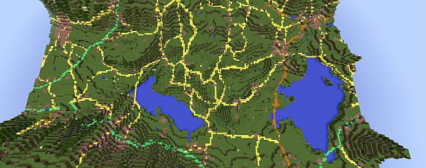
I think I'm hovering over Nempnett Thrubwell, a village near Bath that I went on a road trip to after discovering there was a place called Nempnett Thrubwell. I know it's there, because I'm on a Minecraft map that was created by the Ordnance Survey people, and if your job is to make maps then you probably know where all places are. But all I can really see are blocks. Lots and lots of blocks. That is until I start to pull my character into the air. The higher I go, the more sense I can make of the world they've made: a Minecraft map of Great Britain, built from their mapping data. It's yours to download below.
It's a simplification of Britain, made by intern Joseph Braybrook. He fed the data into two of the map maker's programs—OS Terrain and OS VectorMap District—and the result is a 4.3 GB representation of the island.
When you start, it's initially underwhelming and just a splodge of blocks that's supposed to be Southampton. To get the most out of the map, take to the skies and look down. What was once indistinct becomes clearer. Because of the compression, it's not going to be a one-to-one recreation (it's 1-50: I just ran across Lundy Island, a three-mile long island off the coast, in 10 seconds), but with enough distance you can make out the lay of the land.
Want to play with it? The map's here, and you can even use their location tools and a minecraft convertor to find specific places.
Thanks, PEECEEGAMESENN.


